 Ohio Ag Net | Ohio's Country Journal Ohio Ag Net | Ohio's Country Journal
By Brianna Smith
For farmers, weather is more than just coffee shop talk; it’s often a deciding factor in how the growing season will go. Ohio has experienced weather extremes over the last two years, from wet, cold springs to hot, dry summers. Drought conditions in the state have affected crops and pastures. More than ever, farmers want to understand not only the forecast but also the broader trends shaping rainfall, temperature, and weather conditions.
That’s the focus of Aaron Wilson, state climatologist of Ohio and assistant professor with Ohio State University Extension. Wilson says Ohio has historically been behind when it comes to weather monitoring, but new technology is beginning to close the gap.
“We’ve relied on co-op stations and volunteer observers for years,” Wilson explained. “That data has value, but it doesn’t always give farmers the insight and confidence they need to make in-field decisions. Mesonet stations change that.”
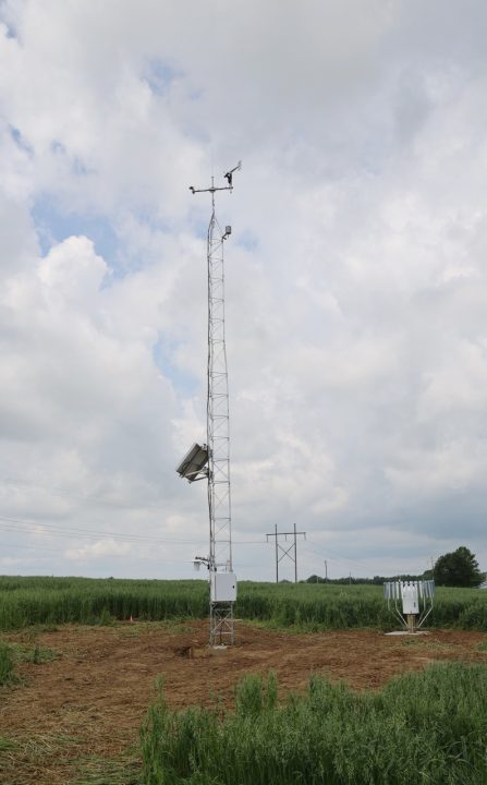
Mesonets are state-of-the-art weather stations designed to capture detailed, local conditions. Unlike backyard rain gauges or older research instruments, mesonets track multiple layers of data simultaneously. Each station measures wind speed at two heights, monitors soil moisture and temperature down to half a meter, and uses weighing gauges for more accurate rainfall readings. They can also capture temperature inversions. For farmers managing tight windows to do field work, this kind of detail matters.
“Farmers need to know when an inversion might increase spray drift risk, how quickly soil moisture is being lost during a dry spell, or how deep frost is going in the winter,” Wilson said. “These stations provide that level of detail.”
Currently, Ohio only has a handful of the new mesonet stations, with five presently operating and several more in progress. By the end of October, Wilson hopes to have nine stations built.
“I’ve got a grand vision,” Wilson said. “It’s 88 stations, so one per county in the state of Ohio. We would love to work with folks at the county level if there’s interest.”
Ohio is historically behind in weather reporting technology. While National Weather Service co-op stations and volunteer observers have reported weather data for more than a century, the network is sparse and inconsistent compared to the mesonet systems operating elsewhere.
“Oklahoma has had a statewide mesonet for 30 years with nearly 200 stations. Kentucky has more than 80. New York put in more than 160 in recent years,” Wilson said. “In Ohio, we currently have five.”
That limited coverage means gaps in understanding the conditions that farmers face in the field. Radar often struggles to detect what’s happening at the surface, especially in areas like northwest Ohio, where a “radar gap” leaves forecasters without ground-level detail. Citizen science networks like CoCoRaHS, where volunteers measure daily rain and snow, help fill in some blanks, but they can’t match the accuracy and consistency of a mesonet station.
“Mesonets have become the backbone of weather information,” Wilson said. “They improve severe weather forecasting, help researchers build agricultural models, and give farmers reliable, real-time data they can actually use. Other states have secured public and private funding to make this happen, but Ohio hasn’t made that leap yet.”
As farmers still recover from the 2024 drought, Ohio’s weather in 2025 has not been any kinder.
“From April through July of 2025, we had the eighth-wettest period on record statewide,” Wilson said. “Then August hit, and some areas saw less than a tenth of an inch of rain all month. That rapid shift into drought is something we’re seeing more frequently.”
In southern Ohio, some counties logged nearly 30 inches of rain between April and June, only to turn bone dry by August. In the northwest, areas of Wood and Henry counties were the first to slip into drought after weeks of minimal rainfall. As of Oct. 7, about 3.5% of the state was in extreme drought, including Belmont, Defiance, Hancock, Henry, Monroe, Paulding, Putnam, Seneca, Van Wert, and Wood counties.
“The overall trend in Ohio has been wetter springs, up to 20% wetter in some regions over the last 50 years. Summers are either flat or trending drier, especially July and August,” Wilson said. “It means farmers face more of these rapid oscillations from extremely wet to extremely dry.”
Even when precipitation arrives, the intensity has changed. One- to three-inch downpours are happening more often, straining tile systems and increasing erosion.
“What used to be considered a 100-year rainfall event is now showing up every 20 years, or even more frequently in some parts of Ohio,” Wilson said
Temperature trends tell another story. Winters in Ohio are getting warmer, which has shifted plant hardiness zones and allowed more pests to survive through the cold months. Springs are warming too, though summer daytime highs have stayed flat, and in some cases, even trended cooler compared to a century ago.
“If you look back over 130 years, the early part of the 20th century had a lot more 100-degree days in Ohio,” Wilson said. “It was overall drier in the 1930s.”
A shift in humidity has also caused weather patterns to change.
Historically, between early June and the end of July, Dayton International Airport spent 66% of the time with a dew point temperature at or above 65 degrees, which meteorologists classify as muggy. About 30% to 35% of the time, dew points topped 70 degrees, falling into the “oppressive” category of humidity.
In July 2025 alone, there were 28 days with dew points above average.
“The Gulf of Mexico was full of moisture, just flowing up into the Midwest,” Wilson explained. “We had a stalled-out weather boundary that provided a focal point for repeated rounds of showers and storms. It kept our overnight lows extremely warm.”
June and July overnight lows topped records across Ohio, with many nights at 77, 78, or even 79 degrees.
For crops, those muggy nights mean less recovery time and altered growth patterns. The swings have been sharp, too.
“At the end of May, after a cold month, we were 60 to 100 growing degree days below average,” Wilson said. “By the end of July, we were 200 to 300 growing degree days above average.”
Wilson is quick to point out how valuable weather monitoring can be for farmers.
“When you combine on-farm yield data with high-resolution weather observations, we can start building predictive models,” he said. “That helps us better understand things like tar spot outbreaks in corn, white mold in soybeans, or the risk of vomitoxin.”
Partnerships with OSU Extension educators and programs like eFields make that connection practical. By tying weather data to yield maps and management practices, researchers and farmers can identify what weather variables matter most at different stages of the growing season.
Expanding Ohio’s mesonet requires funding and collaboration. Each station costs approximately $25,000 to $35,000 to install, with additional resources required for calibration and maintenance. Support so far has come from groups like the Nationwide Insurance AgTech Innovation Hub, the College of Food, Agricultural and Environmental Sciences, the State Climate Office of Ohio, and the Ohio Soybean Council. Wilson hopes more partners will step forward as the value of localized weather data becomes clearer.
“Ultimately, this helps with profitability, sustainability, and risk management,” Wilson said. “It’s about giving Ohio farmers the best information possible to make tough decisions in a changing climate.”
To stay up to date with the latest drought conditions and weather updates, visit go.osu.edu/ohiodrought.


